Map Developers Center
Build custom transit maps using datasets from Metro Transit.
Here’s free access to a wealth of data from King County to create custom transit maps. Over 50 data sets are available, including bus stops, bus routes, adverse weather routes, time points, neighborhoods, fares, bike lockers, fare zones, transit centers, park and rides and MORE.
Many King County Geographic Information Systems (GIS) layers can be found in the KCGIS Data Portal. These layers are available for download at no cost. Available formats are ESRI file geodatabase, shapefile, and KML.
See what’s available
A good way to get started is to check out our Data Format Primer.
Also check out:
- A description of the types of metadata available from King County.
- Our Spatial Data Catalog, which is a complete list of all available datasets.
- The spatial datasets that use Metro Transit data.
- A list of all maps available through the King County GIS center go.
Frequenty Asked Questions
How much does King County data cost?
The Transit data provided in this feed is provided for your use free of charge.
Can I sell this data to others?
No. You cannot sell this data. But you are free to use this data in applications you would like to sell and charge users for the application.
I discovered a problem with the data. How can I report it?
Please tell us about any inconsistencies or problems with our data by e-mailing us at PublicTransitData@kingcounty.gov.
How will I learn if there are changes that I need to know about?
We now have a subscription list just for developers. Sign up to get announcements of new developer’s resources, workshops and events.
How often is the data updated?
King County Transit has three service periods per year that change in February, June and September. Within each of the three major service periods we may make minor alterations and fine-tune our service and data every other week. Minor alterations on that schedule usually happen throughout the first half of the major service period and then taper off and cease in the final half.
When is the data for future service periods made available?
Typically the data for a future service period is ready for publication about four weeks ahead of the service change date. Because each major change in Transit service is different from the past, we occasionally need to adjust the timeline to account for these variations.
Check out the maps developers have built that use Metro Transit data!
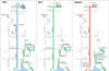
Aurora Corridor 1997-2011-future
Developer: Oran Viriyincy
The past, present and future of transit service on Aurora Ave is shown through this set of three maps made from GIS data, historical maps and proposed service.
Developer: Oran Viriyincy
GIS data was simplified to create this map showing all bus services from central Ballard in a London-style diagram.

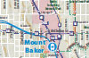
Southwest Seattle: 2009 Transit Service
Developer: Patrick Jankanish
This map compilation was built from GIS layers in the KCGIS Data Portal to show the mix of travel options and pathways in Southeast Seattle including bus, rail, bike lanes, trails, stairs, and more.
Promote your map!
Did you build a cool map with our data? Want to tell the world? If your map uses our data, we'll link to it. Use the link below to e-mail us a link and brief description.
Contact us
Do you have questions about our data? Please use the link below to send us your questions. We will get back to you with as much information as possible.
Keep informed
We want to make sure you know what we’re doing. Sign up to get announcements about new developer’s resources, workshops and events.